September 22, 2005
MEGA RITA
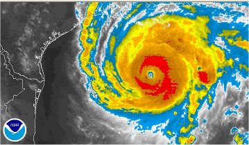
Safe to say that Friday night at this time, the northeast Gulf coast of Texas and the adjoining southwest Louisiana coastline region will be having one helluva bad evening. Hurricane Rita is taking aim and bearing down with Category 3 winds of 140 mph. That's a far cry from the 175 mph that were clocked earlier today, but at this point, it's barely relevant, given that the storm surge tends to do more damage than the wind.
Fresh from a soggy weekend of enduring Hurricane Ophelia and hunkered down in the Side Salad Weather Center's Doppler 12,000 North Carolina Bureau, Willie Drye, author of Storm of the Century: The Labor Day Hurricane of 1935, continues to pump out great reports for the National Geographic Web site:
Hurricane Rita is expected to make landfall at or near Texas's Galveston Bay late Friday or early Saturday. Forecasters think Hurricane Rita will weaken some before it comes ashore, but will still arrive with winds of at least 130 miles an hour (210 kilometers an hour) and inflict massive damage."It's the difference between tremendous damage and devastating damage," Beeler said. "It'll still be very bad. Texas hasn't been hit by something this strong in quite a while."
Like all of the recent powerful Gulf of Mexico hurricanes, Hurricane Rita underwent a period of rapid intensification. The storm climbed from a Category Two to a Category Five hurricane in less than 24 hours.A Category Two hurricane has winds of 96 to 110 miles an hour (155 to 177 kilometers an hour). A Category Five hurricane has winds exceeding 155 miles an hour (250 kilometers an hour).
Hurricane Rita's rate of intensification approaches the most rapid intensification on record for any tropical cyclone. In 1983 a typhoon in the Pacific Ocean underwent an intensification that boosted its top winds from 75 miles an hour (120 kilometers an hour) to 173 miles an hour (278 kilometers an hour) in less than 24 hours.
Beeler said the warm waters of the Gulf of Mexico have fueled the recent spate of monster hurricanes.
"For the last few years, the Gulf has had very warm waters," Beeler said. "That doesn't cause hurricanes to develop, but it acts like a high-octane fuel for them."
And while New Orleans is again escaping a direct hi, there are more than a few worried about whether the temporary measures will hold back the additional storm surge and rainfall.
As the folks at Wizbang (reciprocal Salad linker) noted with an alarming photo accompanying this comment:
That is the state of repairs on the 17th street canal. If you look at the height of the repair it is about as tall as the track on the crane. If you look next to the crane you will see the guy in the blue shirt... The track is about up to his waist.Posted by Jeff at September 22, 2005 11:59 PMSo, plus or minus a little bit, we can handle about 3 feet of storm surge. Rita is hitting to our west but she has 175mph winds and about a 30 foot storm surge. Do the math.
Ah, sychophant soup, tasty. ;)
Posted by: Cupie at September 23, 2005 01:10 AM